
Fantasy Map Review II: Greyhawk
For links to all instalments in this series, go here.
Second instalment in the series gives a strong showing with another iconic example - The Flanaess as depicted in the World of Greyhawk Folio from 1980:
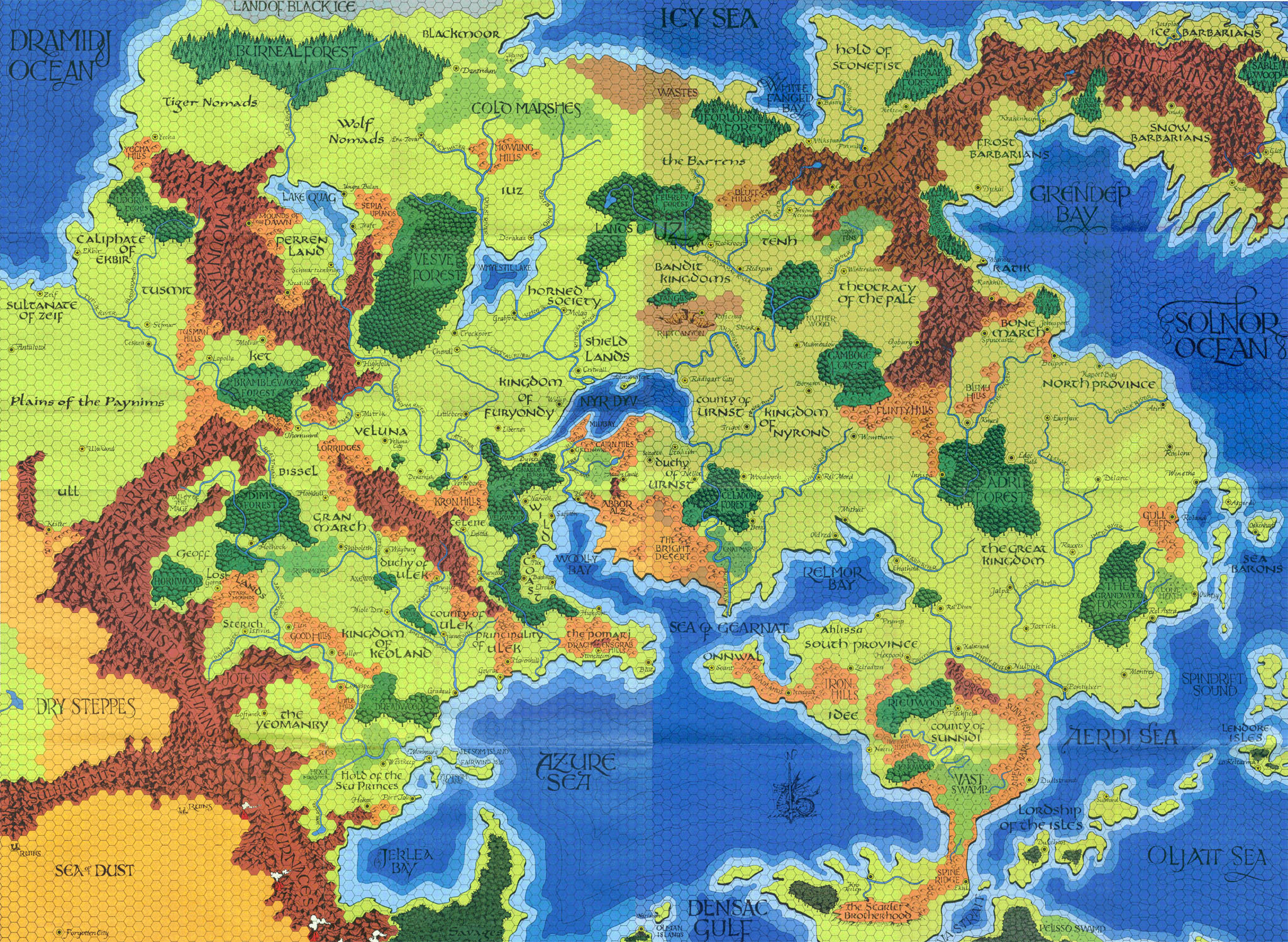
First Impressions: It is with a certain amount of awe that I delicately unfold my original Darlene maps from the Greyhawk folio - Still in top notch shape after 35 years thanks to the sturdy paper the folio edition were printed on. From a gamer's perspective, you can't ask for more - They are huge, sturdy enough to take to the table and have a lot going on. Not as beautiful and flavourful as Middle Earth, but still a work of art. And hex-mapped. All awesome.
Further Thoughts: The Flanaess is to me the gold standard of how to draw up a setting map. No borders are drawn and none are needed. The geography naturally points out how regions are shaped and interact with each other. You can learn a lot about the Flanaess just from this map:
The Sheldomar Valley countries obviously have close relations, being tucked in together a bit away from the rest of the world the way they are.
The Baklunish are somewhat isolated from the rest of the Flanaess. Perrenland seems almost like a kingdom list in time, sheltered in the mountains like that.
The Old Aerdy East and Old Aerdy West are somewhat cut off from having relations due to the savagery of central Flanaess - The Horned Society, Iuz and Bandit Kingdoms will put a bummer on any trade route.
Go north of all the evils lands, effectively cutting off the north from civilization, is plenty of land - Blackmoor, Cold Marshes, Barrens, Stonefist, Frost/Snow/Ice Barbarians, tiger/wolf nomads. The lands forsaken by law and civilization are sizeable and feel suitably isolated from civilised southern lands.
Appealingly, the 'safer' area to go through from old Aerdy East to Old Aerdy West is adventuring area numero uno - The Wild Coast. I love its placement on the map and its relations on the map. Anywhere is in feasible reach for an adventurer on the wild coast. The Nyr Dyv and Wooly Bay gives you plenty of means of getting around. For adventurers in the Wild Coast, the Flanaess is your oyster. The whole Nyr Dyv/Wooly Bay/Relmor Bay area is just really well constructed for bringing these lands into contact with each other and opening routes of travel.
No wonder the City of Greyhawk is such a big fish - The Nyr Dyv is obviously a really central area. The rivers flowing into it pass through 16 different countries! And itself opens into the Whoolly Bay - From there, the Sheldomar Valley and great kingdom are in reach. You could get on a boat all the way up north in Blackmoor, sail through the vast Burneal forest, across Lake Quaag in Perrenland, through Veluna and Furyondy into the Nyr Dyv, past the city of Greyhawk into the Wooly Bay and then the Azure Sea and from there set sail to anywhere from Hepmonaland to Irongate or the Hold of the Sea Princes. I love that - Simply looking at the map gives you real ideas about trade routes and itineraries.
Overall, these maps not only have great production value for gaming, the way the various nations and realms are set up against each other really stimulates immersion and the sense of possibility and adventure.
Style: 4/5
Substance: 5/5
The Darlene maps are a solid pick for best fantasy gaming map of all time and sets the gold standard for how to make a gaming map.
Second instalment in the series gives a strong showing with another iconic example - The Flanaess as depicted in the World of Greyhawk Folio from 1980:
First Impressions: It is with a certain amount of awe that I delicately unfold my original Darlene maps from the Greyhawk folio - Still in top notch shape after 35 years thanks to the sturdy paper the folio edition were printed on. From a gamer's perspective, you can't ask for more - They are huge, sturdy enough to take to the table and have a lot going on. Not as beautiful and flavourful as Middle Earth, but still a work of art. And hex-mapped. All awesome.
Further Thoughts: The Flanaess is to me the gold standard of how to draw up a setting map. No borders are drawn and none are needed. The geography naturally points out how regions are shaped and interact with each other. You can learn a lot about the Flanaess just from this map:
The Sheldomar Valley countries obviously have close relations, being tucked in together a bit away from the rest of the world the way they are.
The Baklunish are somewhat isolated from the rest of the Flanaess. Perrenland seems almost like a kingdom list in time, sheltered in the mountains like that.
The Old Aerdy East and Old Aerdy West are somewhat cut off from having relations due to the savagery of central Flanaess - The Horned Society, Iuz and Bandit Kingdoms will put a bummer on any trade route.
Go north of all the evils lands, effectively cutting off the north from civilization, is plenty of land - Blackmoor, Cold Marshes, Barrens, Stonefist, Frost/Snow/Ice Barbarians, tiger/wolf nomads. The lands forsaken by law and civilization are sizeable and feel suitably isolated from civilised southern lands.
Appealingly, the 'safer' area to go through from old Aerdy East to Old Aerdy West is adventuring area numero uno - The Wild Coast. I love its placement on the map and its relations on the map. Anywhere is in feasible reach for an adventurer on the wild coast. The Nyr Dyv and Wooly Bay gives you plenty of means of getting around. For adventurers in the Wild Coast, the Flanaess is your oyster. The whole Nyr Dyv/Wooly Bay/Relmor Bay area is just really well constructed for bringing these lands into contact with each other and opening routes of travel.
No wonder the City of Greyhawk is such a big fish - The Nyr Dyv is obviously a really central area. The rivers flowing into it pass through 16 different countries! And itself opens into the Whoolly Bay - From there, the Sheldomar Valley and great kingdom are in reach. You could get on a boat all the way up north in Blackmoor, sail through the vast Burneal forest, across Lake Quaag in Perrenland, through Veluna and Furyondy into the Nyr Dyv, past the city of Greyhawk into the Wooly Bay and then the Azure Sea and from there set sail to anywhere from Hepmonaland to Irongate or the Hold of the Sea Princes. I love that - Simply looking at the map gives you real ideas about trade routes and itineraries.
Overall, these maps not only have great production value for gaming, the way the various nations and realms are set up against each other really stimulates immersion and the sense of possibility and adventure.
Style: 4/5
Substance: 5/5
The Darlene maps are a solid pick for best fantasy gaming map of all time and sets the gold standard for how to make a gaming map.


<3 true all
ReplyDelete